Hike Number 14, Sunday May 3, Hollywood Stairs Circuit

Distance: 2 miles

Elevation Change: 266 ft

Temperature Day of Hike: 80 degrees

Directions: From Franklin Avenue, head north on Beachwood Drive. Once you pass the Beachwood Café (Beachwood and Westshire) park anywhere.

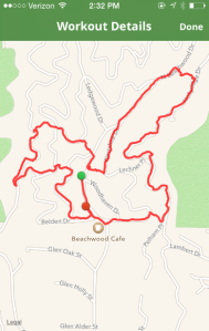
Abby: On Saturday, Sasha sent me a text with a link to the Hollywood Stairs Circuit and asked if I was up for it on Sunday. We’d been talking about trying an “urban hike” for a while, so despite my feelings for running stairs, I agreed. When we parked at Beachwood Canyon, we weren’t sure of cell phone service, so we sat for a bit to take screen grabs of the route.

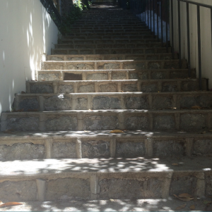
While Sasha did this, I googled how many stairs and it was in the 800’s. From the car, the trek to the first set is a small climb up Beachwood Canyon Drive. When you reach the stair case, you meet a set to haul up. Per my Google search, this was 124 steps. At the top, you are greeted by signage directing you to the right for the second set.

1

As you continue up the canyon to the second set, take advantage of the incredible views of the Hollywood Sign and Downtown LA.

2

The second staircase was a bit hidden, but since we knew the address markers, we were able to spot it, and make our way down. At the top of the second set, we were welcomed by more beautiful views of Downtown LA and now the Griffith Observatory.  Once we reached the bottom, we continued on to the third set.

b2

Sasha: When we started the blog, we really set out to find and explore hikes in the LA area that didn’t require too long a drive, but were still challenging. The past month has been pretty hectic for both of us, so we were excited to take the opportunity to find a local “hike” that would take us to a neighborhood we weren’t too familiar with. The idea of the urban hike really appealed to us too – we were hoping to use some of our hikes as excuses to explore urban Los Angeles.

The third staircase was probably one of my favorites – it is a divided set that apparently was once home to a water feature that has been converted to planters. We descended 138 steps, and found our way back to Beachwood Drive, where we found staircase number four.

3

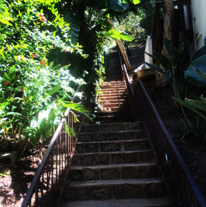
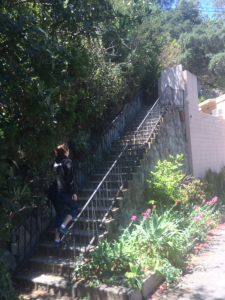
The fourth staircase was hidden between houses on Beachwood Drive, and at 144 steps, was the first of the more challenging ascents. This staircase was a little overgrown and steep, so we definitely were grateful for the just in case handrail. Both Abby and I have been known to take a tumble on a hike, so we were fairly cautious on the steep, narrow stairs. Once we got to the top of set four, we were treated to more spectacular views of the city. From the top, we headed back to Beachwood Drive, to find the largest ascent, staircase five.

5

Abby: At 176 steps, the fifth set was the most challenging, in my opinion, so I was eager to see what was next on flight six. It was a nice descent back to Beachwood Drive, although as Sasha said, the steps were super narrow, so I took them a little slowly to avoid an “Abby fell down the stairs on a hike” story.

Sasha:

The blow by blow directions:

From the intersection of Belden Drive and Woodshire Drive:

  1. Head north on Woodshire Drive to staircase 1, on the left just before 2795 Woodshire Drive and ascend 124 steps.
  2. At the top (Belden Drive) head left.
  3. At the fork in the road, bear right (Flagmoor Place) and at the intersection at Durand, continue uphill on Durand.
  4. Staircase 2 is located past 2954 Durand; descend 117 steps.
  5. At the bottom of set 2, you will be back on Belden Drive. Continue on Belden, cross Rogerton, and find staircase 3 just before 2950 Belden Drive. Descend 138 steps.
  6. Once you reach the bottom, cross Beachwood Drive and head to the right.
  7. Staircase 4 is located after 2800 Beachwood Drive; ascend 144 steps.
  8. At the top of set 4, turn left and head downhill on Westshire. Once you reach Beachwood, continue on, crossing Belden to staircase 5.
  9. Find staircase 5 after 3020 Beachwood Drive. Ascend 176 steps to the top.
  10. At the top of set 5, turn right onto Hollyridge Drive. Continue on Hollyridge past Pelham, and find staircase 6 just past 2831 Hollyridge Drive. Descend 149 steps.
  11. You’re done! Take a break at the Beachwood Café, or reverse the series for a more challenging hike.

Pro’s:

– Amazing views

– Quick and challenging

– Not too crowded

– Easy for us to get to

Con’s:

-Stairs were a little narrow

– May need to do it a few times to really feel a burn

Holy shit view factor: 6/10. The views aren’t totally unique to the hike, but always beautiful

How good your ass will look after: 8/10. Climbing stairs is no joke.

Post hike grub spot: Beachwood Cafe. We decided to stop there because it was close, and because we saw Secret Service hanging out outside. We were hopeful to see Hillary, but were unsuccessful in that endeavor.
1 2 3

Hike Number Seven, February 22, 2015: Hollyridge Trail to the Hollywood Sign

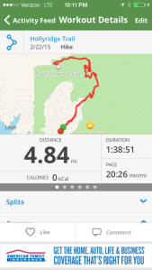
Distance: 4.84 miles round trip

Elevation Change: 853 feet

Temperature day of hike: 60 degrees

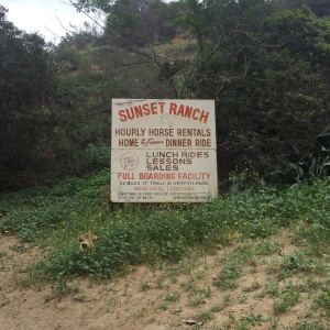
Directions: From Franklin Avenue, head north on Beachwood Drive. Beachwood leads to a dead-end on Sunset Ranch, which is where this hike begins. There is plenty of parking on Beachwood, just pay close attention to the parking signs to make sure you’re safe to leave your car. We parked 2 stop signs south of the entrance to the ranch, about ½ mile from the trailhead.

Abby: Since it was Oscars Sunday, and I had guests from the east coast visiting, we decided to hike up behind the Hollywood Sign. It was pretty overcast in the morning, and we weren’t certain about what traffic would look like because of the awards show, but we were excited for the hike, the views, and the Instagram opportunities.

As we approached the trail entrance, we noticed that there were signs reading, “no Hollywood Sign access” but as we drove to the gate, a security guard let us know we could walk to the sign, just not drive to it. He also informed us that we had to park pretty far away, so be prepared for a small hike before the big hike. Also be certain to read the parking signs on the streets, because they were a bit confusing.

Sasha: Beachwood Canyon is one of my favorite places in Los Angeles – it’s lush, green, very private and the former home of the Hollywoodland community (and much Hollywood history.) I was really excited to share this beautiful place with Abby and our guests, so I was nervous that access to the sign would still be cut off. After talking to the security guard at Sunset Ranch, we drove back down Beachwood Drive, two stop signs from the entrance to the Sunset Ranch and found easy parking. Along the trek to the trailhead, there are plenty of beautiful homes to be distracted by (hello 1920’s Mediterranean Villas!) and not much sidewalk to walk on, so be weary of fast cars.

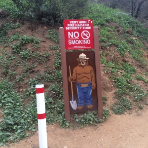
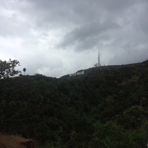
Once we made it to the gate, we continued up a short, steep hill until we reached the trailhead to the right. It’s pretty clearly marked, with a life-sized Smokey the Bear cutout admonishing visitors not to smoke, as fires start and spread easily in the dry mountain terrain. We hiked up a short bit, before hitting a T-junction (the Hollyridge Trail, where Smokey warns you one last time not to light up), and we veered left to continue up near the top of Mount Lee. We were almost immediately hit with a gorgeous view of the Hollywood sign, a perfect photo op for our out-of-towners.

h3 h4

We continued on, and caught a quick whiff (and view) of the horse stables below us to the left, which reminds me that we haven’t discussed the horse poop yet. There is a lot of it, so be prepared to jump over fresh piles every few steps. I’m actually pretty sure the “dirt” path is horse-made. After another quarter mile, we made a sharp left turn onto the Malibu Service Road (going right takes you deeper into Griffith Park) to continue up to Mount Lee. We got a few views of the Observatory and miles of Griffith trails to the east.

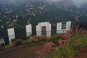
After another quarter mile, we turned right at Mount Lee Road, which begins the steep, paved climb to the top of the mountain. As we were admiring some interesting street art, it began to rain and I made my first promise to the group that we were almost at the top of the mountain. In reality, the last part of the climb is about a mile long, so as we all cried about the cold, (east coast guests included, who had escaped a blizzard to come to LA) as we continued to climb up the hill. About half way up the hill a local affiliate news trucks passed us and we were convinced someone had died from hiking in the rain. As we followed the news trucks, I made a few more promises that we were almost at the top, and we finally rounded the final bend where we saw the back of the “H” through the chain-linked fence that keeps hikers off the giant letters. Despite what you saw in “Friends with Benefits.”

h5h9h2

We continued onward, passed the “OLLYWOOD,” and saw the news trucks parked at end of Mount Lee Road, near the radio towers that top the mountain. It turned out the story they were telling wasn’t about a death from the rain, but rather, Oscars coverage from the Hollywood Sign. Because, we live in LA and saw many celebrities hiking that morning. (We didn’t, but we did stand in the cold rain, took many pictures and admired the views of the rain-soaked city below us.)

h0

Abby: Despite the freezing downpour, the views were unbelievable. There was something romantic about seeing the entire city under a hazy cloud. Not being from Los Angeles, I was also pretty mesmerized at the fact that we were standing behind the Hollywood Sign. After taking in the views, and shivering from the cold, we headed back down the trail. Because of the rain, it was pretty slippery so we treaded carefully. We were surprised a few times by some rocks that were falling from the top of the mountain, so we had to be extra careful, but I’m assuming that was also due to rain.

h1

When we made it to the entrance gate, we were reminded that we still had a ways to go to make it to the car. Once we reached the warm, dry vehicle, we agreed it was time for some hot food and fresh cocktails.

Pro’s:

  • Incredible views
  • Wide, well kept trails
  • Clearly marked

Con’s:

  • No shade
  • Beware of rocks falling
  • Tons of horse poop

Tips:

  • Don’t forget a camera

Holy Shit View Factor: 10/10

How Good Your Ass Will Look Afterwards: 8/10 This is a pretty steep climb

Post hike grub spot: We were all pretty hungry and ready for a cocktail after hiking in the rain, so we decided on Birds Café in Hollywood. Their menu is great; filled with options from kale salads to comfort foods like macaroni and cheese. They also had $3 mimosas! Definitely recommend trying this place.

h01

Tracking the hike: MapMyHike has been our go-to with these hikes, and it was reliable again this weekend.

h8 h7 h6